We want Newmarket's streets and parking to work well for everyone, so we're seeking your feedback on our proposals.
What did we look at?
We’ve taken a detailed look at how all public parking works in the area. This included surveying all types of parking spaces, checking how full they are throughout the day, how long people stay for, and where parking rules are often broken.
We’ve also spoken with the Waitematā, Albert-Eden and Ōrākei Local Boards and the Newmarket Business Association to understand what’s important to the community.
We have considered future growth projections and planned commercial and residential developments, so that parking meets everyone's needs today and well into the future.
What we’re addressing
- Loading zones are in high demand and often full throughout the day.
- Some zones near busy roads pose safety risks.
- Our enforcement team are noticing problems on streets like Carlton Gore Road, Manukau Road, Gilgit Road and Broadway.
- Streets such as Broadway, George Street, Khyber Pass Road and Carlton Gore Road are often full during peak times.
What the data tells us:
What we're proposing
Public parking
We know many people rely on their cars to get to Newmarket, whether for work, shopping or appointments. So, we want to make sure there’s reliable access to parking where and when it’s needed the most, easing congestion and keeping parking turning over in the right places to support businesses.
Proposed time restrictions
To improve turnover in Epsom North and Newmarket, we’re proposing 2-hour time limits on some streets:
All day, every day:
- Gilgit Road and parts of Almorah Road to support access to Auckland Grammar School and Allevia Hospital Epsom.
- Omana Avenue and Savannah Street to encourage turnover in high-demand areas.
Monday to Friday (8am–6pm):
- Lion Place (cul-de-sac and southern side).
Monday to Sunday (8am-6pm):
- St Marks Road (between Robert Hall Avenue and Remuera Road).
Simplifying paid parking zones
We’re planning to:
- Merge all paid parking areas in Newmarket into one zone for consistent pricing and operating hours across the week.
- Extend the zone to include St Marks Road (from Broadway to the SH1 overbridge).
Clearer parking rules
To make it easier to understand where you can and can’t park, we’re proposing:
- A clearway on Almorah Road (between Maungawhau Road and Gilgit Road).
- ‘No Stopping Off Roadway’ signs on Gilgit Road.
Broken yellow lines:
- On Almorah Road to provide for safe movement in both directions.
- At 8 and 10 Roxburgh Street to replace parking triangles.
- On the western side of Ada Street, near Mamie Street and Belmont Terrace, to improve visibility for turning movements at the intersection.
Improving safety at intersections
We’re also proposing a new ‘Stop’ sign and line markings at the Mamie Street–Ada Street intersection in place of parking.
Specialty parking
Regular parking spaces don’t work for everyone. We provide other types of parking, in place of general vehicle parking, where it is needed. This includes pick-up drop-offs, mobility, loading and servicing, motorcycle, bicycle and scooter spaces.
Quick stops – 10-minute pick-up and drop-off spaces
To make short stops safer and easier, we’re proposing new 10-minute spaces at:
- 1 Rockwood Place (southern end) and Gilgit Road (between Mountain Road and No. 4) for safer student drop-offs near Auckland Grammar School.
- 14 Morrow Street – for taxis, deliveries, and drop-offs near the town centre and train station.
- Western side of Broadway (between 239 and 265) – to meet high demand.
Working with schools
We’d like to connect with local schools to explore parent parking options and restrictions, especially around Mountain Road and Manukau Road, to help reduce congestion and keep students safe.
Improving access – mobility parking
We’re planning to:
- Add 2 new mobility spaces at 2 Morrow Street.
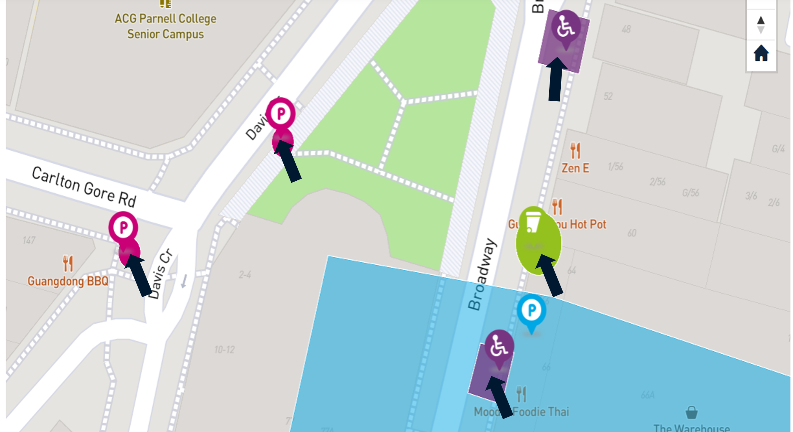
- Relocate the mobility space outside 48 to 66 Broadway to better accommodate both a van and standard vehicle. Upgrade the existing space at 469 Khyber Pass Road to meet accessibility standards and improve footpath access for wheelchair users.
Supporting business – loading zones
To meet growing demand, we’re proposing to add new loading zones at:
- 2 Clayton Street.
- Kingdon Street (near Carlton Gore Road).
- 8 Roxburgh Street
- 1 McColl Street
- 3B Melrose Street
- 5 Kent Street
- 142 Broadway
- Between 239 and 265 Broadway (on the western side).
More parking options for everyone
- Motorcycles: New spaces at 11 McColl Street and Carlton Gore Road (north side near George Street).
- Cycles: New parking on Kingdon Street.
- Scooters: New designated parking at key locations, so that scooters are not cluttering the footpath, including: Broadway, Mortimer Pass, Morrow Street (outside Westfield), Teed Street, Balm Street, Khyber Pass Road, Crowhurst Street, Osborne Street, George Street, Carlton Gore, Kingdon Street, Park Road, Davis Crescent, and Morgan Street.
Creating a pedestrian friendly Newmarket
We’ve heard how important it is for Council to invest in Newmarket’s future. Making Newmarket easier and safer to walk around in supports local businesses. Thoughtful changes to Newmarket’s footpaths, kerbsides and intersections can foster a people-friendly environment and make the area more accessible. We’re planning several improvements to make Newmarket more accessible, welcoming, and easier to navigate:
Enhancing Broadway with wider footpaths
In partnership with the Newmarket Business Association, we’re planning to widen the footpath along Broadway (from Remuera Road to Khyber Pass) in stages over the next 5+ years. This will improve the experience for shoppers and visitors and create more room for street improvements. We’re also looking at changes in the area that will help the traffic move better. See staging on right.
Better access to Maungawhau/Mt Eden
We’re proposing a safe and accessible pedestrian link between the footpath and the entrance to Maungawhau/Mt Eden.
Wider footpaths in residential streets
Streets like Melrose Street, Roxburgh Street, McColl Street, Ada Street, Belmont Terrace, Lauriston Avenue, Middleton Road, and Mamie Street will have wider footpaths. This will make it easier for more people to get around and allow for future street upgrades as the area grows.
Smarter waste collection for local businesses
We will work with Auckland Council to improve how waste is collected in busy areas like Broadway, Kingdon Street, Clovernook Road, Railway Street, Remuera Road, and surrounding streets. This means cleaner streets and more space for people.
Parking proposals map
Zoom into a specific street/area on the map to see what is proposed.
If you want to view more information about a specific proposal, select the rectangle/circular shape that is next to the icon. This will display a pop-up box with more information about the proposal.
Interactive map
Have your say: Parking in Newmarket
What happens next?
Once you’ve provided your feedback we will look for common themes, review any direct property access concerns and ensure we haven’t overlooked anything important. After that, we’ll meet with the Waitematā and Albert-Eden and Local Boards to review everything together and decide on the next steps.
We’ll then share the outcome with you, so you know what’s happening and what to expect.
Frequently asked questions
Newmarket is one of Auckland’s busiest retail, commercial and residential areas. With more people living, working and visiting, demand for limited street space is growing.
With approximately 6,000 parking spaces available in the area (including 3,000 in Westfield), we’re prioritising the remaining public spaces to ensure fair and equitable access for everyone.
Exciting developments are on the way which will boost foot traffic and add convenience for locals and visitors. We’re improving access with new loading zones and clearly marked pick-up/ drop-off areas. These upgrades are designed to support local businesses, ease congestion, and make Broadway more welcoming for everyone.
We want Newmarket’s streets and parking to work well for residents, businesses and visitors.
We regularly make small changes to parking in Newmarket but now’s the opportunity to take a big picture look and consider all kerbside space in the area collectively.
We know convenient parking is important for supporting local shops, cafes and services. Our approach is designed to keep parking spaces turning over so that more customers can find a park close to local businesses, giving smaller shops better access for customers as opposed to commuters who park all day. We’re also making loading zones, short-stay, mobility, e-scooter and motorcycle parking so it’s easier for people to pop in, shop locally and support a variety of businesses.
Parking at Westfield Newmarket is free for a limited time, after which fees apply, as the carparks are privately owned. We do not manage these private parking areas but inevitably need to manage the effects that spill out onto the street. Although we are not able to offer free parking in the first two hours, we still offer competitive prices to private parking.
Newmarket currently has three paid parking zones with different time limits and prices. We are proposing to make these consistent across the area to simplify parking and better manage demand. Parking occupancy is high throughout Newmarket, often exceeding 85 percent, which makes it difficult to find a space.
To help keep parking available and support turnover, we are applying the pricing already in place in the busiest parts of Newmarket to surrounding areas, which are just as busy. When demand exceeds availability, a small price adjustment helps free up spaces, reduces the need to drive around looking for parking, and supports local businesses by making it easier for customers to visit. This approach helps people find parking more easily, keeps traffic flowing, and encourages short stay visits to shops and services.
We know school drop-off and pick-up is a busy time for families. That’s why we want to make sure any changes to parking support safe and convenient access around schools. We are proposing adding a 5-minute space near Auckland Grammar and St Peters to support the school run. If you have any feedback on these, we would like to hear from you. We haven’t proposed any changes near the other schools within this area.
This proposal has been developed by the Newmarket Business Association. We have been working closely with them to understand the needs of the locality and help make Broadway a more vibrant and welcoming destination. Widening the footpaths is an important first step as it creates space for trees and greenery (and more outdoor dining), improves safety for people walking, and enhances the overall look and feel of the busy street.
These changes also benefit local businesses by making the area more attractive to visitors, encouraging foot traffic, and creating a more enjoyable environment for shopping, dining, and spending time. A more pedestrian-friendly Broadway helps reinforce Newmarket’s identity as a premier destination and supports a thriving local economy.
Broadway is one of Auckland’s busiest pedestrian corridors, and with the opening of the City Rail Link set to bring even more foot traffic, there’s a unique opportunity to permanently repurpose select parking spaces to create wider, more welcoming footpaths.
The opening of the City Rail Link will transform how people connect with Newmarket, making it faster, easier, and more reliable to access one of Auckland’s premier retail, business, and lifestyle destinations. With more frequent train services and reduced travel times, CRL will unlock new opportunities for growth, foot traffic, and vibrancy in Newmarket, supporting local businesses and enhancing the area’s appeal as a central hub for work, shopping, and leisure.
Additionally, Newmarket is part of the Future Connect - Auckland Transport's Network Plan which outlines the Strategic Transport Network for each mode of transport (both now and in 10-years’ time). You can access the interactive map to see what’s planned for the area. A full refresh will be developed with Council and NZ Transport Agency this year, showing out to 2037, to assist Council as they develop their next set of transport investment decisions in 2027.
Our streets are under increasing pressure to cater for a wide variety of needs within a finite road space. The roads in Newmarket are already at their maximum width and there simply isn’t room to add more lanes without removing shops, homes or footpaths.
Widening the road is also very expensive and disruptive and may not always solve congestion. Our focus is on managing the space we already have more effectively – through better parking management, public transport, walking and cycling options. This approach makes it easier for more people to move around safely without the need for major roadworks.
Auckland Council is in charge of implementing new off-street parking options, including park-and-ride facilities and parking buildings. The construction and maintenance of parking buildings is a significant investment, typically costing millions of dollars that must be recovered through rates.
The objective of this project is to optimise the management of existing parking resources. The introduction of new off-street parking facilities is not within the scope of this programme. Instead, the focus will remain on maximising the utilisation of current assets to minimise costs for ratepayers.
The goal of these projects across Auckland is to better manage the parking we already have. Sometimes we are able to add angle parking in place of parallel parking to increase the number of parking spaces.
There is already a large number of angled parking on side streets and we have not identified any more streets that we could add this to as part of this process. Introducing new off-street parking facilities will not be part of this program.
Introducing these changes will be staggered. Some proposals will be implemented within the next year, while others may have a long-term focus so the conditions might not be ready for us to implement these straight away. Once we have agreement on our proposals with the Local Boards, you still start to see these changes rolled out over the next ten years.
No, there are no plans for additional bicycle or scooter infrastructure beyond parking as part of this project.
We are looking at how we move traffic through Broadway and Khyber Pass Road and we will come back to you early in the new year to get your feedback on the proposed changes.